
Have Camera, Will Travel
Have Camera, Will Travel

 At 1.5 miles a trail junction splits and the Telephone Canyon trail continues on, while Marufo Vega turns and climbs sharply up 400′ over a ridge into another drainage:
 A look back up Telephone Canyon from the saddle:
 From the high bench, you get your first look at the top of the del Carmen mountains, still nearly 4 miles away:
 The trail wind across the desert into secondary drainages with interesting dikes and rock formations:
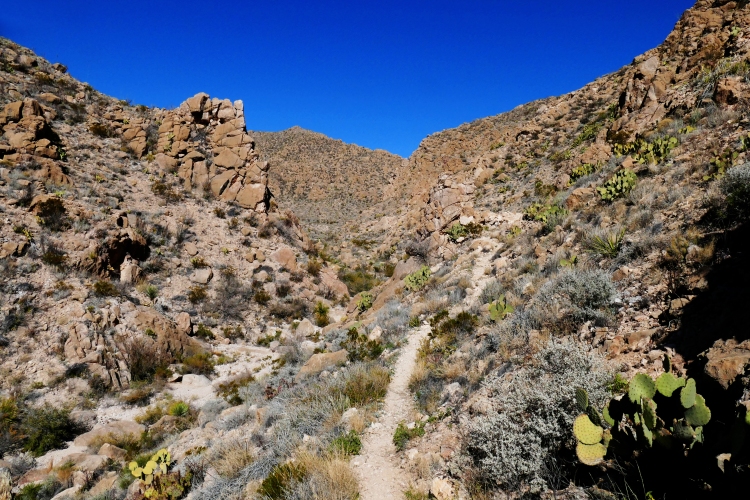

 At 3.5 miles the trail splits, forming a 5-mile loop that eventually drops 1000 feet down to the Rio Grande River, then follows the river for 1.5 miles before climbing back up the 1000 feet and re-joining at this point:
 Following the drainage marked “South Fork,” the trail winds through the hills and out onto a wide, flat park before disappearing over another low saddle to begin the traverse around an escarpment and the final push to the bench above the Rio Grande River:

 The first look eastward at the “Lower Canyons” of the Rio Grande, dropping over 1000 feet below the trail down to the Rio Grande River, carving its way southeast, the border between Mexico and Texas:
 This photo taken on another trip showing the river from a closer proximity to its channel:
 Around one more corner, the first look at the Sierra Madiera del Carmen mountains, looming to a height of nearly 8000 feet just across the river in Mexico, the highest point being the small, thin spire called “El Pico” just to the right of the pointed direction of the trail:
 Another half mile and the panorama of the Del Carmens rises along the southern skyline, beginning their stunning color change as the sun begins its long, slow journey into sunset:


 The Milky Way is generally not visible at this time of the year, because we are not looking at the most dense spiral that is so familiar during the spring, summer and fall months, but out here the skies are so dark that the less dense spirals of the Milky Way are visible, occasionally streaked with a passing meteor:


 Next morning, the sun breaks upon the mountain peaks lowering over the lower canyons of the Rio Grande:


 And so begins the 5.2 mile journey back to the trailhead, with an overview of the last 1.5 miles of trail, following the old path of the Ore Trams, cabled buckets much like ski lifts, that hauled fluorspar ore, used in steelmaking, from Mexico to the railhead in Marathon for processing:

 And so ends the tour of the southern loop of the Marufo Vega Trail. This is not a hike for the summer, so if you plan to go, the cooler days of late fall, winter, or very early spring should be your goal. Hope you enjoyed this rather lengthy visit to my backyard.
I really enjoy these trips you take. I must come join you someday. Sure looks different than our area. I can imagine just how HOT it must get around mid-summer.
That’s why we come see you in summer, and you belong here in winter. Actually, at our house up here at 4100′ altitude it seldom gets above 100. By June the monsoonal flow from the Pacific gives us clouds and it gets cooler, usually low to mid 90’s, and very dry. Much better than Dallas. Thanks for the comment.
That was a nice trip. Thanks for letting me tag along. At least going this way me feet don’t hurt. By the way Dan is cancer free once again. Praise God!!!
Love Kathy
I saw your post after the doctor exam following his last round of radiation. Time to once again rejoice!
What a great hike. The mountains at sunset and sunrise are especially beautiful. It’s always interesting to watch the play of light. And I can’t remember the last time I’ve seen the Milky Way like that. It’s probably been fifteen years. I’ve been in places where it should have been possible, but clouds or a full moon diminished the effect.
Thanks for providing such an image-rich post.
I have been looking at your site here for a couple of hours. Very nice. I appreciate your hard work assembling the photos and comments, having done a bit of it myself. I also love the Marufo Trail. I have been exploring Big Bend for 24 years and am just scratching the surface, which is good; I’d hate to run out. I post my photos at Flickr and have an Album of my April 2016 day hike on the Marufo Trail at: https://www.flickr.com/photos/pepesreturn/albums It was 100º or so that day but I did find shade here and there, next to east – west cliffs.
I should mention that on Flickr, using the Slideshow view will keep ads or the “sign in” nags from pestering the viewer who does not sign in. In Windows, the F11 key works well with the slideshow mode, for full screen.